It seems impossible that a country below sea level can exist. However, The Netherlands lies in the middle of a delta of three major rivers on land, mainly below sea level. So, how much of The Netherlands is actually under sea level?
26% of The Netherlands is below sea level, and 59% of The Netherlands is vulnerable to flooding by the sea in case of high tide and severe storms. Rising sea levels and ongoing land subsidence are causing the Netherlands to sink below sea level even more.
Read on to discover how the Dutch claimed their land from the sea and held on to it for centuries.
Table of Contents
- How Average Is The Average Sea Level?
- Which Part Of The Netherlands Is Below Sea Level?
- Map Of The Netherlands Below Sea Level
- How Much Of The Netherlands Is Reclaimed Land?
- How Much Is The Netherlands Below Sea Level?
- Is The Netherlands Sinking?
- How Do The Dutch Keep The Water Out?
- Visualizing Water That Is Higher Than Land
How Average Is The Average Sea Level?
How much of The Netherlands is under the sea level looks like a simple question, but you must realize that the sea level varies by about 1.5 meters between low and high tide. This sea-level variation makes it difficult to calculate the percentage of The Netherlands below sea level.
Determining how much of The Netherlands is below sea level is only possible if we compare heights with an average sea level, meaning the average sea level between low and high tide.
The average sea level is called 0-meter Normaal Amsterdams Peil (NAP), and heights in the Netherlands are all calculated relative to 0-meter NAP.
However, the difference in sea levels between low and high tides can become much more than 1.5 meters under certain conditions. Larger variations between low and high tides are possible because the sea level is influenced by the sun and moon’s gravity on the sea’s water.
When the sun, moon, and earth are in line, their influence on sea levels is more than usual, and we speak of spring tide. Also, storms can significantly increase the sea level, and then we speak of storm surges.
A spring tide with a storm surge causes exceptionally high sea levels. For example, a spring tide with incredibly high sea levels (due to a storm surge) caused the flooding in Zeeland in 1953 that killed almost 2000 persons.
Which Part Of The Netherlands Is Below Sea Level?
The official Government Agency responsible for measuring heights in The Netherlands is Actueel Hoogtebestand Nederland (AHN).
The AHN data are freely available for everybody, and the map below is from their website and shows the elevations in The Netherlands in great detail.
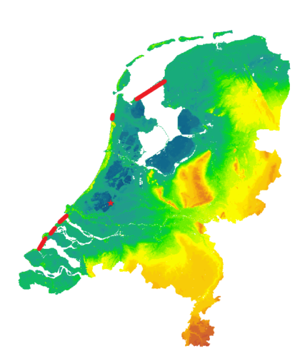
The colors of the map are self-explanatory:
- Dark blue is land well below sea level and found in the polders in the country’s western part and the IJsselmeer.
- Dark green is land around sea level and vulnerable to flooding.
- Light green, yellow, and orange are above average sea level.
If you wonder how much below sea level you are, you can use a Dutch website: will I be flooded? You can fill in your ZIP code in The Netherlands to check how much below sea level you are on this website.
For example, Amsterdam is 1-2 m (3,3 – 6,6 feet) below sea level and could not exist without continuous water drainage.
Map Of The Netherlands Below Sea Level
This map shows what The Netherlands will look like if the low-lying areas are flooded. Cities like Amsterdam and Rotterdam will be completely underwater. 59% of The Netherlands can be flooded, devastating for this densely populated country.
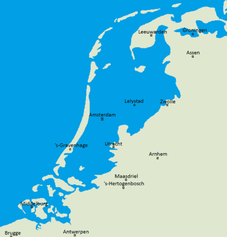
The provinces of North and South Holland will be completely underwater.
In my case, I found it reassuring that our house is only 2.5 meters below sea level. Therefore, if needed, we can keep dry feet if we flee to the first floor!
All joking aside, this is a scenario that Dutchmen hardly ever think about because we trust our water engineers completely.
The map above clearly illustrates the danger of flooding in the Netherlands. However, what is particularly frightening is that it is still an underestimation because this map does not show the effect of rising sea levels due to climate change.
Therefore, I have written another article on how rising sea levels due to climate change will affect The Netherlands.
What is most concerning is the publication of Dutch scientists in 2022 in which they demonstrated that the sea level rise in the North Sea for the Dutch coast has accelerated from 1,7 ± 0,3 mm/yr to 2.7 ± 0.4 mm/yr in recent years.
That is an unprecedented acceleration of the sea level rise and concerning because it is still unclear if the acceleration in sea-level rise may increase even further.
How Much Of The Netherlands Is Reclaimed Land?
The Netherlands is the undisputed World Champion when it comes to land reclamation.
Overall, 7.200 km² of the Netherlands is reclaimed land, around 20% of The Netherlands. There are about 80 different land reclamation projects in The Netherlands, of which Oostelijk Flevoland is the most extensive land reclamation with 540 km².
How Much Is The Netherlands Below Sea Level?
Given that 26% of The Netherlands is below sea level, you may wonder where and how deep the lowest point of the Netherlands is.
The lowest point in The Netherlands is 6.78 m (22.2 ft) below sea level and is located near Nieuwerkerk aan den IJssel. Ongoing land subsidence in this polder causes the lowest point to sink 1.0 cm (0.4″) deeper below sea level annually.
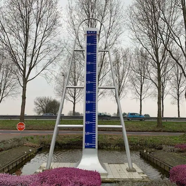
There is even a monument (see above) in Nieuwerkerk a/d IJssel to show the exact place of this lowest point. So you must climb to the top of this monument to stay above sea level if the sea ever comes back. The only problem is that there will be only one place at the top of this monument, and the rest will have to swim.
Is The Netherlands Sinking?
To answer the question if the Netherlands is still sinking, you need to know that the soil in the low-lying western part of The Netherlands primarily consists of peat. Peat is a type of soil that becomes denser by extracting water.
The Netherlands is still sinking because the required drainage of low-lying peat areas increases the density of peat, causing ongoing land subsidence at a speed of 0.8 – 2.0 cm per year.
The Netherlands is caught between a rock and a hard place. The Dutch need to drain their land below sea level to avoid flooding, but the ongoing drainage causes the Netherlands to sink further below sea level.
Short-term, The Netherlands has no other choice than ongoing drainage, but the Dutch are well aware of the long-term problems of the ongoing land subsidence causing the Netherlands to sink further below sea level.
The sinking of the peat areas caused two severe long-term problems for The Netherlands:
- Land subsidence at a speed of 2 centimeters per year results in 2 meters of land subsidence in 100 years, jeopardizing the long-term viability of The Netherlands.
- Peat releases a large amount of carbon dioxide when it becomes more compressed. The released carbon dioxide of the Dutch peat areas will contribute to global warming, which, in turn, will lead to rising sea levels. The land subsidence and rising sea levels made it twice as difficult for the Dutch to keep their land dry.
Life goes on in The Netherlands as if nothing about this is scary. Looking at the picture above, you will note a highway running next to this monument. I drove many times over this highway and never realized that I was at the country’s lowest point when I passed this monument.
Living below sea level does not keep us occupied as we live our lives. But, honestly, we enjoy one side of this coin tremendously because you can best explore the Netherlands by boat.
There are so many canals and rivers that connect different lakes that it never gets dull.
How Do The Dutch Keep The Water Out?
The Dutch have devised an ingenious two-step water and hydraulic management system to create and hold onto their land below sea level. The way the Dutch have achieved this remarkable feat is one of the “7 wonders of the modern world “.
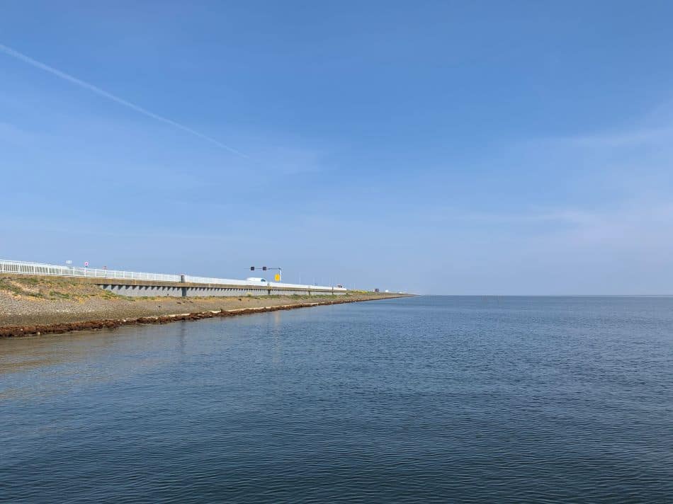
- The Dutch closed the weak holes in their coastline with the North Sea as a first step. Most of our coast consists of naturally formed dunes above sea level. Unfortunately, this natural defense was weakened by inlets that allowed devastating floodings with a combination of storms and high tides.
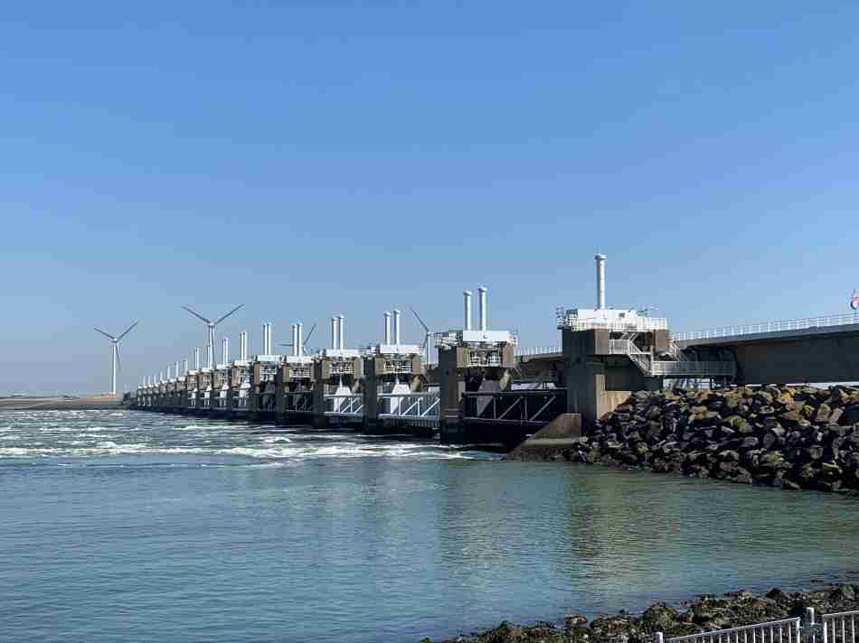
- The red lines indicate the dikes to close the holes in the natural defenses on the map above. These dikes are the Afsluitdijk, the Hondsbosche Zeewering, and the Delta works in Zeeland.
- As a second step, the Dutch built dikes around low-lying parts of their country, like lakes and swamps, and drained these lakes and wetlands to turn them into fertile farmland. Land reclamation started in the 17th century with the Beemster polder, which used to be the Beemster lake before being drained with windmills.
Water is continuously pumped to higher canals, which, in turn, transport the water to the rivers to allow it to flow back to the sea. In the lower-lying parts of the country, hundreds of pumps are working daily to pump the water out and keep it out.
The water volume that the Dutch have to drain annually to keep their land dry is an astounding 19 trillion liters of water (5 trillion gallons).
The YouTube video How The Dutch Dug Up Their Country From The Sea provides an excellent visualization of the entire process of land reclamation. It is a fantastic video with more than 1.3 million views.
This process can never stop, or the water in these parts of The Netherlands will flood the land again. Fortunately, they have backup pumps if more pumps run into technical issues.
Visualizing Water That Is Higher Than Land
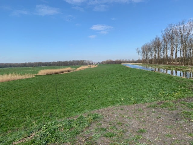
I understand that it is hard to visualize land lower than water. It does not make much sense at first sight. Therefore, I have taken a picture to show you what it looks like when the water is higher than the land.
This picture is taken close to my home and demonstrates water above the land. This picture is taken on top of a drainage canal, looking downwards to the reclaimed land.
Since water is pumped continuously into the drainage canal, the land below the drainage canal will not be flooded and will stay dry.